
|
|
 |
 |
 |
HER Reporting
One of the aims of the Jigsaw project is to encourage and facilitate groups to report their work and findings to the Cambridgeshire Historic Environment Record (CHER), and to write reports. See the reporting page here for further advice and contact details.
OASIS
Cambridgeshire Historic Environment Team have supplied Jigsaw with some guidelines to completing OASIS forms. These can be used by Jigsaw groups when registering their findings on the OASIS online database.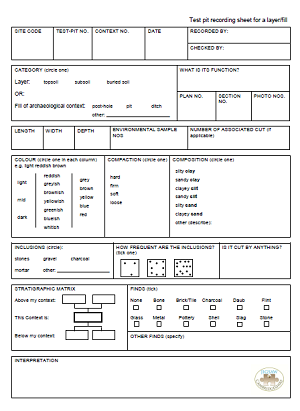
Context Recording
Jigsaw groups are encouraged to use our context recording sheets for recording layers/fills and cuts in testpits and archaeological features. They are designed to record true archaeological contexts (e.g. topsoil, subsoil, any archaeological features) rather than the 10cm spit methodology.
Layer/fill context sheet
Cut context sheet
Report Writing
We also encourage groups to write formal reports of their findings. Feel free to use our Report Pro Forma to make this process easier. For a detailed guide to what to put in archaeological reports, and which sort of report you should write, read our guide: Introduction to Archaeological Report Writing
QGIS Mapping
Once the text parts of a report have been written, many community archaeology groups stall at finding maps for their site which are within copyright, and may wish to create maps of their own and digitise their sections and plan drawings. QGIS is a relatively easy-to-use free software which does all of the above, as well as allowing users to plot find spots in fieldwalking.
The Jigsaw guides are based on two courses run in 2014 and 2015 using the 2.6.0 version of QGIS. Please download the guides with the data files to work through the exercises. We hope that having worked through these practical examples you will be able to create maps and plans of your own.
An Introduction to QGIS - Level 1
QGIS Level 1 data - you must download this for the guide to be useful. Download all four exercises - select the zip files for each exercise for fast download, rather than manual download of each of the individual files.
QGIS Guide Level 2 data - you must download this for the guide to be useful. Download both exercises - select the zip files for each exercise for fast download, rather than manual download of each of the individual files.
Covington Training Dig Report
Historical Research
Historical Research Methods for Archaeologists - a guide for archaeologists wishing to conduct historical research.